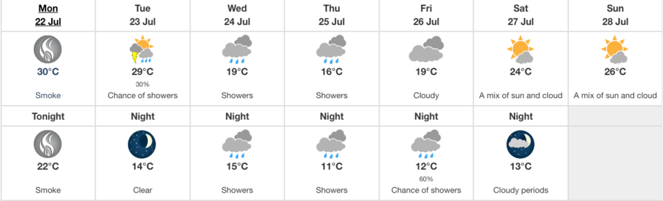
Residents in the Town and Country area may be happy to hear that the constant heat will be on hiatus in the middle part of the week, with Environment Canada forecasting showers and mid-teens temperatures Wednesday, Thursday and Friday.
The reprieve won’t come until then however — Monday is set to be 30 C, with plenty of smoke from forest fires to the north and northwest. The smoke should dissipate just in time for a cloudy Tuesday morning, with a chance of showers in 30 per cent of the coverage area. Wildfires continue to burn in the M.D of Opportunity and the Lac La Biche and Fort McMurray Forest Protection Areas. The daily high will be 29, before temperatures plummet to a mere 14 degrees overnight.
Wednesday morning will bring in warm showers, with a high of 19, and the rain should continue on-and-off overnight and into Thursday.
Thursday’s high will be 16 degrees with more showers. The rain should stop by Friday, although clouds are expected to remain which will keep the weather “cool” at 19.
Saturday and Sunday should both be sunny with a few clouds, with highs of 24 and 26 expected each day.
As always, temperatures are measured in the shade so the hot days will be even warmer than advertised in the sun. Be sure to keep yourself and others, including pets and children, out of the full sun on hot days.
An air advisory warning remains in place for the entire north half of Alberta as of 5:45 a.m. Monday morning.


